
Earth Data Delivers New Thermal Imaging Services
Earth Data recently expanded the comprehensive list of its field-oriented consulting services with the addition of thermal imaging services.
Using a new state-of-the-art FLIR Zenmuse XT2 thermal sensor in conjunction with its DJI Matrice 210_V2 RTK network-enabled drone allows Earth Data to integrate a high-resolution FLIR thermal sensor and a 4K visual camera with DJI’s leading stabilization and machine intelligence technology to quickly transform aerial data into powerful insights. The advanced thermal sensor provides high sensitivity imaging for infrastructure monitoring, energy inspections, firefighting, search and rescue missions, and more. With a fully integrated dual payload, Earth Data’s five, FAA-licensed drone pilots can capture actionable thermal and color visible data in a single flight, saving time, money, and even lives.

By combining the flight stability, gimbal technology, mobile app integration, and image transmission of the powerful DJI 210_V2 RTK with FLIR’s industry-leading thermal imaging technology, Earth Data now offers its clients the ultimate solution for reliable, rapidly-deployable aerial thermal imaging. Earth Data’s DJI Matrice 210_V2 RTK drone lets us simultaneously deploy two imagers below the aircraft to fly thermal and visible cameras at the same time. We typically pair the Zenmuse XT2 thermal sensor with the Z30, 30x optical zoom for remarkable detail and clarity.
Earth Data’s FLIR radiometric thermal sensor and 4K visual camera integrate seamlessly with DJI’s enterprise drone platform to increase efficiency—saving customers valuable time and money in the field. The drone and thermal camera are housed in weather-resistant enclosures to allow pilots to fly in rain, snow, smoke, and fog.
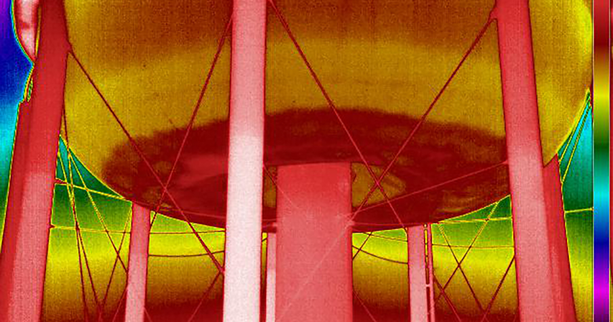
A drone-mounted thermographic survey transforms data into insights in real-time by capturing and recording temperature data at the pixel level to deliver actionable intelligence. Earth Data’s FLIR Zenmuse XT2 camera includes temperatures alarms, heat tracking, and more than a dozen color pallet choices to facilitate imagery viewing and analysis. On one recent project, Earth Data performed a thermographic survey of a 1-million-gallon elevated tank before its scheduled maintenance. The thermal survey was able to identify the extent of sediment accumulation in the base of the tank, which assisted utility engineers and operations personnel to develop an efficient, cost-effective maintenance plan.
Earth Data’s high-tech drone inspections are a cost-effective way to not only inspect large structures like an elevated water tank but provide environmental monitoring and infrastructure management too. This technology allows our clients to address current problems and identify risks in advance. It can be easy to do if you only know how to look. That’s why we work hard every day to help our clients see things in a different light.
For more information contact us here, or call 410.758.8160.